6 terrifying images reveal Hurricane Laura's breathtaking magnitude from space
NASA satellites and other spacecraft captured these compelling images of the category 4 hurricane as it hurtled toward America's Gulf Coast.

Hurricane Laura made landfall over the coasts of Louisiana and Texas early Thursday morning. The category 4 hurricane left a wave of destruction behind, with wind speeds of 150 miles per hour and heavy rain. More chaos could follow this week, as forecasters warn of a storm surge and further flood damage.
As it moved from the Gulf of Mexico toward the US coast, both NASA satellites and astronauts onboard the International Space Station (ISS) kept a watchful eye on the storm, providing imagery and data used by forecasters to analyze Hurricane Laura.
Together, space scientists captured six terrifying images of this huge storm as it grew in strength and barreled into the coast.
The Visible Infrared Imaging Radiometer Suite (VIIRS) instrument aboard Suomi NPP provided a nighttime image of Laura during the early morning hours of Aug. 25.
In the morning of August 25, NASA's satellites released infrared images of Hurricane Laura as it was leaving the Caribbean Sea and moving into the Gulf of Mexico.
At the time, Laura was not yet a hurricane, but the nighttime images revealed the eye of the storm developing in size. The images also showed that the storm was already over 350 miles in diameter.
The Visible Infrared Imaging Radiometer Suite (VIIRS) on NOAA-20 acquired this image of Hurricane Laura at 2:50 a.m. Central Daylight Time on August 27, 2020, about two hours after the storm made landfall
From these data and further observations over the next two days, NASA Earth Observatory researcher Joshua Stevens compiled this incredible image of the storm as it made landfall over Louisiana.
An image captured by the Planetary Society's LightSail 2 solar sail showing the storm in the lower left corner.
On Monday, August 24, the Planetary Society's LightSail 2 captured an image of Hurricane Laura as it made its way across the Gulf of Mexico. The storm can be seen in the lower left corner of the image, with the solar sail hovering above.
"To all near this mighty storm, stay safe out there!" the Planetary Society tweeted on Tuesday.
The National Oceanic and Atmospheric Administration's GOES-East satellite captured this view of Hurricane Laura on Wednesday morning, August 26.
The images show lightning bursting from the convection taking place inside the storm, as the winds swirled at a speed of 115 miles per hour.
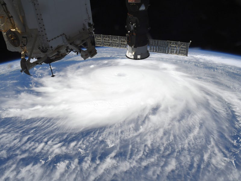
Astronaut Chris Cassidy captured this image of the storm from the ISS.
Meanwhile, astronauts flying onboard the ISS, which orbits at a distance of 254 miles above Earth, watched as Hurricane Laura brewed below.
NASA astronaut Chris Cassidy captured this image of the storm from onboard the spacecraft, revealing the massive eye of the storm on Wednesday before it made landfall.
An animation showing the progression of the storm from August 20-26.
To get a sense of how the storm changed over the course of this week, NASA-NOAA’s Suomi NPP satellite captured visible infrared imagery of Hurricane Laura as it progressed from August 20-26. The images show its birth in the Atlantic, and track it as it moved from the Caribbean Sea into the Gulf of Mexico.
The US National Hurricane Center has more updates on the hurricane here.