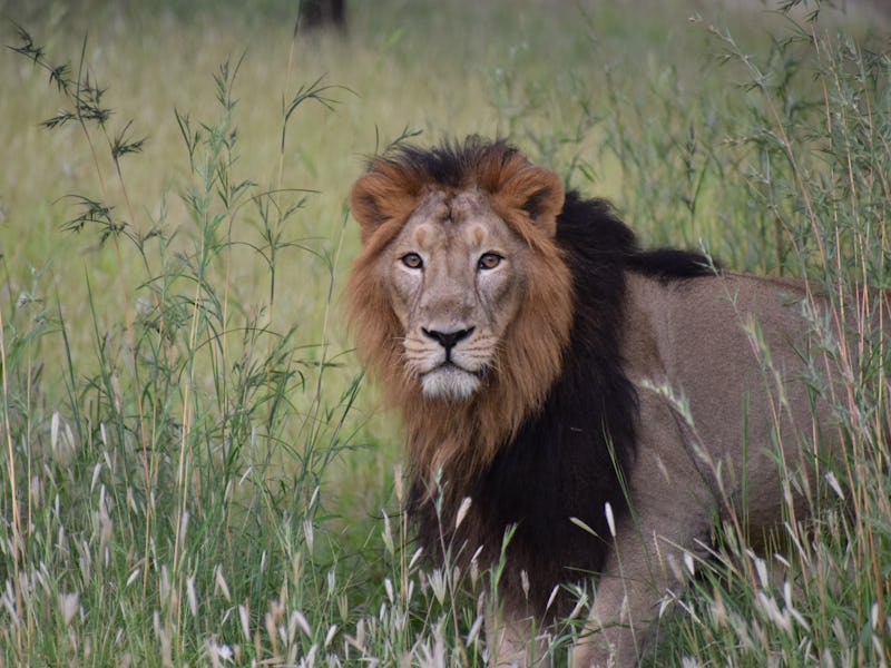
Can better tracking save India’s endangered lions?
Indian researchers come up with a new way to count and track Asiatic lions — one of the world's most-endangered big cats.

Around the globe, endangered species are being threatened by habitat destruction, poaching, and climate change. A critical part of the fight to save a species is knowing just how many — and where — the animals are in the first place. But for creatures living in remote locations, or those that shy from humans, getting an accurate count is particularly difficult.
Now, researchers from India have developed a new method to track endangered Asiatic lions that they say gives a more accurate — and thus, a more useful — count of these big cats. Getting a better handle on how many of them are left in the wild could be a game-changer for their conservation — and ultimately, their survival.
The new method involves looking at the spatial distribution of Asiatic lions, or Panthera leo persica, and using that to calculate the density of the lions living in any one place. To test the method, the researchers looked at lions living in a protected habitat in the Gir Forests in Gujarat, India. They also looked at the lions’ prey distribution, including two types of deer, to see how it correlates with where the lions live.
Asiatic lions are an “an icon of conservation success," the researchers say. In the Gir Forest, populations have risen from 50 to 500 individuals, thanks to better protections. But they are still under severe threat of extinction.
"The only population of Asiatic lions in the world survives in the Saurashtra landscape" of India, the researchers point out.
In traditional wildlife count studies, scientists use a “total count” to estimate the population of a species. Similar to a human census, total counts aim to put a number on how many individuals live in a given area. But these estimates are imperfect at best. They often overlook some individuals, while counting others more than once, the researchers say.
To get a better estimate, the researchers use the lions' features — whisker patterns and body marks — to identify specific, individual lions, and then gather information about their spatial distribution. The technique is called “spatially explicit capture recapture,” and it addresses the problems of skipping or double-counting individual animals.
The research, led by Keshab Gogoi from the Wildlife Institute of India, appears in a study published Wednesday in the journal PLOS ONE.
Predator and prey
The study describes how the technique identified 67 individual lions from a total of 368 lion sightings in the Gir Forests. Within a forest area of about 725 kilometers, that brings the lion density to roughly 8.53 lions per 100 kilometers squared.
An Asiatic lion in India.
In addition to lions, the researchers used the new tool to estimate deer populations — namely the sambar and chital deer — to see how prey population influences lion distribution. Curiously, there was no strong link between the two.
Rather, lion density was more clearly associated with humans. There were more lions near baiting sites set up for tourism.
The findings illustrate the heavy impact humans can have on the social and ecological roles of lions, the researchers say. But the work need not end with lions — this tracking method is scalable and could help illuminate these kinds of trends across the globe, the researchers say. Ultimately, it may uncover some unfortunate truths about just how much we humans are messing with nature.
"Conserving this sub-species with the use of best science and management is a global priority and responsibility," the researchers say.
"Our research paper addresses this priority by developing a robust approach to their population assessment and monitoring which can be used for all lion populations across the world."
Abstract: Asiatic lions (Panthera leo persica) are an icon of conservation success, yet their status is inferred from total counts that cannot account for detection bias and double counts. With an effort of 4,797 km in 725 km2 of western Gir Protected Area, India, we used polygon search based spatially explicit capture recapture framework to estimate lion density. Using vibrissae patterns and permanent body marks we identified 67 lions from 368 lion sightings. We conducted distance sampling on 35 transects with an effort of 101.5 km to estimate spatial prey density using generalized additive modeling (GAM). Subsequently, we modeled lion spatial density with prey, habitat characteristics, anthropogenic factors and distance to baiting sites. Lion density (>1-year-old lions) was estimated at 8.53 (SE 1.05) /100 km2 with lionesses having smaller movement parameter (σ = 2.55 km; SE 0.12) compared to males (σ = 5.32 km; SE 0.33). Detection corrected sex ratio (female:male lions) was 1.14 (SE 0.02). Chital (Axis axis) was the most abundant ungulate with a density of 63.29 (SE 10.14) as determined by conventional distance sampling (CDS) and 58.17 (SE 22.17)/km2 with density surface modeling (DSM), followed by sambar (Rusa unicolor) at 3.84 (SE 1.07) and 4.73 (SE 1.48)/km2 estimated by CDS and DSM respectively. Spatial lion density was best explained by proximity to baiting sites and flat valley habitat but not as much by prey density. We demonstrate a scientifically robust approach to estimate lion abundance, that due to its spatial context, can be useful for management of habitat and human-lion interface. We recommend this method for lion population assessment across their range. High lion densities in western Gir were correlated with baiting. The management practice of attracting lions for tourism can perturb natural lion densities, disrupt behavior, lion social dynamics and have detrimental effects on local prey densities.