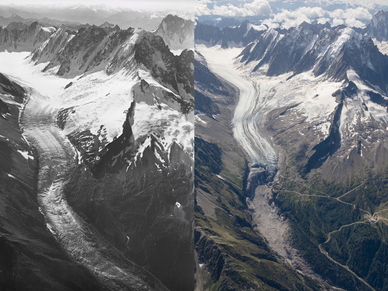
Glacier photos taken 100 years apart highlight the severity of global warming
The peak’s name literally means “white mountain,” but that’s changing.

The idea of rapidly melting glaciers can feel pretty abstract, especially when we see photos of areas still covered in massive ice sheets. Comparing how a place looks today against its history, though, can make the effects of climate change a little more obvious.
On Thursday, researchers in Scotland took aerial photos of Mont Blanc in the Italian Alps that perfectly mirror shots from 100 years ago, and the side-by-side results are striking. Streams in the mountains appear emptier compared to their snow-filled historical counterparts, and outcroppings of rock are exposed where ice once dominated.
Kieran Baxter, Ph.D., a researcher at the University of Dundee and half of the duo that took the new photos, said the experience was both “breathtaking and heartbreaking.”
Photos from 100 years ago gave today's researchers a point of comparison.
“The scale of the ice loss was immediately evident as we reached altitude but it was only by comparing the images side-by-side that the last 100 years of change were made visible,” Baxter said in a press release.
In 1919, Swiss pilot and photographer Walter Mittelholzer flew a biplane over the Alps, photographing Mont Blanc (literally “white mountain” in French), which was then covered in snow.
A century later, Baxter’s team set out to take the “after” pics:
Mer de Glace glacier, then and now.
The researchers used a process called monoplotting to triangulate the camera position of the original photos. They looked at the mountain peaks in the “before” photos to find the exact point from which the images were captured, and they re-photographed the Argentiere, Mont Blanc Bossons, and Mer de Glace glaciers.
Mittelholzer, a pioneer in aviation, helped to popularize commercial air travel in Switzerland — ironic, given that air travel today is a significant contributor to the greenhouse gases causing climate change.
With the impact of air travel in mind, Baxter says his team kept their airtime “as brief as possible” and carefully planned their photos to get the most out of the flight. Plus, they got lucky, flying on a clear day in August.
A view of the Himalayas on the border of Sikkim, India and eastern Nepal, captured December 20, 1975 by a KH-9 HEXAGON spy satellite.
The new side-by-side comparison isn’t the only set of photos showing dramatic ice sheet melting over several decades. Researchers recently used spy satellite images from the Cold War to show glacier retreat in the Himalayas, as Inverse reported in June.
Swedish photojournalist Christian Åslund, working with the activist group Greenpeace, has captured images that show ice loss in the Arctic and other areas over time, National Geographic reports.
One of Åslund’s photos, featuring a person in a boat in front of a mountain, shows a huge glacier all but disappear when compared to its century-old twin. The photo comparison has gone viral on reddit a few times in the past year as this embed shows:
Each of these photo comparisons highlights the massive glacier loss in mountains around the world, much of it happening in remote places that most of us can’t easily access.
Over 20 years of visiting the Arctic, Åslund says he’s seen firsthand how climate change has led to the decline of sea ice and glacier retreat.
“What’s happening in the Arctic is spreading around the whole globe,” he tells NatGeo. “I have also been visiting countries directly affected by climate change — floods, natural disasters, and drought. It is the biggest challenge we face and we must act now before it’s too late.”