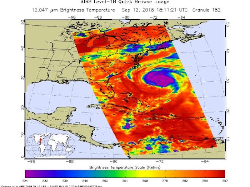
Hurricane Florence: Infrared Image Shows Its Growing Size
A ring of deep, cold rain clouds.

Hurricane Florence may have been downgraded from a Category 4 to a Category 2 storm over the last 24 hours, but it is far from weak. What it lost in wind strength, Florence has gained in size. NASA’s Atmospheric Infrared Sounder (AIRS) instrument captured an image of the storm’s thick cloud shield this week, showing its massive size.
The image, taken at at 1:35 p.m. on Wednesday, shows that Hurricane Florence is now bigger than the entire state of North Carolina, with clouds that extend far beyond the eye of the storm.
The image was created using infrared radiation from Earth, which NASA uses to compile a three-dimensional look at weather and climate. Similar images from the AIRS instrument, and six other sensors on board NASA’s Aqua satellite, have helped scientists understand climate change in the past, such as variations in tropical carbon dioxide levels, how water vapor acts as a greenhouse gas, and the composition of ice over Antarctica.
The Atmospheric Infrared Sounder (AIRS) instrument (before it launched into space).
AIRS and the other instruments on were launched into low-Earth orbit in 2002, and are now managed by NASA’s Jet Propulsion Laboratory in Pasadena, California. Using a high-resolution spectrometer, AIRS can separate the infrared energy coming up from the Earth’s surface into various wavelengths, which when beamed back to the lab on the ground tell researchers about the precise temperature profile and atmospheric composition at different heights.
In the new AIRS image, for example, the ring of deep, cold rain clouds at the center of Hurricane Florence are colored purple.
This image shows Hurricane Florence in infrared light.
Meanwhile, warmer areas along the edges, as well as the hurricane’s eye, are shown in blue, and as the rain clouds get shallower and the air gets warmer, it is depicted in green. The red areas represent mostly cloud-free air moving away from the storm.
By 2 p.m. Thursday, the National Hurricane Center reported that Florence had moved closer — just 110 miles east-southeast of Wilmington, N.C. Florence is churning up “large and destructive waves” over the Atlantic, the agency said. Depending on when those waves reach the shore, they may create a storm surge of up to 13 feet in some areas.
Hurricane Florence is also expected to bring between 20 to 40 inches of rainfall, and because of its slow pace — moving only 150 miles from Thursday night through Sunday morning — the storm may make flooding worse. Duke Energy, a power supplier in the Carolinas, is already warning that nearly 75 percent of its 4 million customers could lose power.
More than 1 million people have been evacuated from the coastal communities across the Carolina, which are still recovering from a bout of summer storms. It doesn’t seem like Florence will give them much of a break.
More Hurricane Florence Reports: