NASA Taps SpaceX to Continue One of the Scariest Climate Studies
A long-running study will continue, thanks to NASA and SpaceX.

One of the coldest, scariest charts on the planet is made from data beamed down from satellites that track the consistent rise in global sea levels. Creeping sea-level rise is plainly visible in locales like Miami Beach and New Orleans, as marshes turn to salty lakes and beaches become ocean. But if you’re NASA, you zoom out, way out, and you can collect data that illustrate how rising sea-levels are a worldwide problem, not just in coastal cities beloved by tourists.
That very research has been going on since 1992, and on Thursday, NASA announced it had struck a deal with Elon Musk’s SpaceX for the Sentinel-6A mission scheduled for November 2020, which will see the study of sea level rise continue through 2027. The mission will send up the first of two identical satellites, and will have two objectives:
- Record how sea levels are rising from space, using radar altimetry (measuring the distance between the ocean surface and the satellite above it).
- Collect “high-resolution vertical profiles of temperature” of ocean waters.
The JASON-CS satellite looks a little like an orbiting Prairie House, but will be the latest in an esteemed line of satellites that measure ocean levels, when it launches in November 2020.
The satellite is called JASON-CS-A, or the “Joint Altimetry Satellite Oceanography Network-Continuity of Service,” and it will circle the Earth from 2020 to 2027. A second satellite, memorably named JASON-CS-B, will go up in 2026 and work until 2033, doing much of the same work.
NASA will spend $97 million on the project that will be launched into space on top of a SpaceX Falcon 9 rocket, leaving from Kennedy Space Center in Florida. (Sometime before that, the JASON-CS-A satellite will travel cross-country, from NASA’s Jet Propulsion Laboratory in Pasadena, California.)
It’s not only NASA doing this work though. It’s a worldwide effort. The National Oceanic and Atmospheric Administration, the European Space Agency, and the European Organization for the Exploitation of Meteorological Satellites are all involved.
NASA’s Sea Level Change portal, in addition to being remarkable trove of data, illustrates how data gathered from satellites since 1992 has created some those worrying trend-lines:
Sea level rise since 1992
From September 1992 to July of this summer, sea levels rose by 84.8 millimeters (3.3 inches), a number that might not seem large, until it’s viewed on global scale. Additionally, the rate of rise goes up each year. The Washington Post reported in July that a 2.2 millimeter-per-year rise in ‘93 grew to a 3.3 millimeter-per-year rise by 2014, based on estimates and research published in Nature in June. Since 1900, sea levels have risen by eight inches, but 2099, NASA projects the ocean will rise by at least three feet.
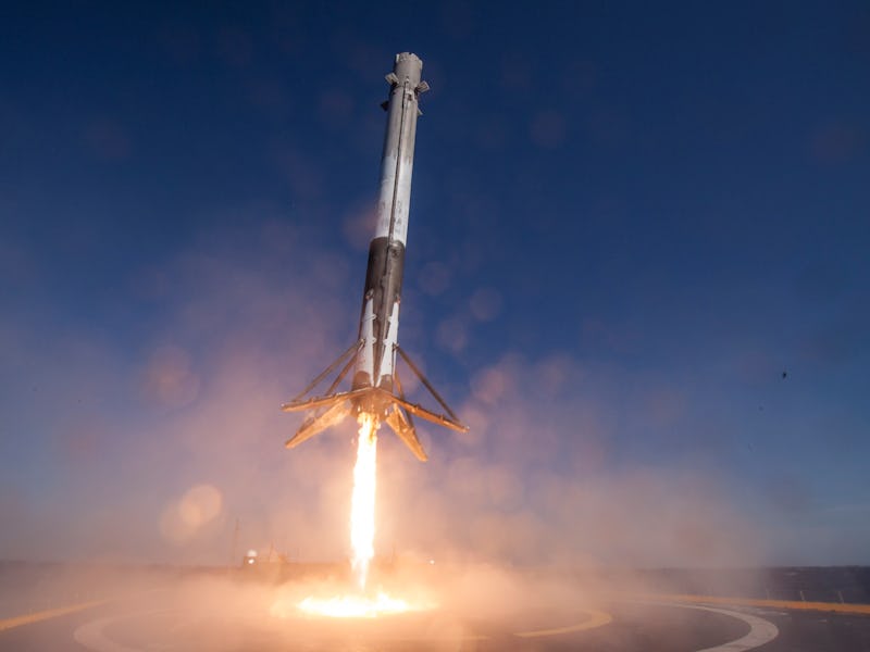
The first stage of a SpaceX Falcon 9 rocket lands on a drone ship.
The news that SpaceX will send up the satellite is also notable, as its launch services have expanded from sending up communication satellites for TV and cell phone companies, to more than a dozen resupply missions to the International Space Station, to launching spy satellites and the crusty-looking X-37B space plane for the Air Force.
SpaceX CEO Elon Musk in Washington, D.C., in 2011.
There’s no doubt this research will be personally important to SpaceX founder Elon Musk, whose other big company, electric automaker Tesla, was started to move the world away from fossil fuels that result in carbon dioxide emissions that clog the atmosphere, heat it up, melt ice on the planet, and raise sea levels.
NASA politically worded its research in an infographic released this month one of its Facebook page, interestingly choosing the world “change” instead of “melt” when referring to Earth’s ice sheets:
“Earth’s climate history shows there have been times when ice sheets rapidly changed and created multiple meters of sea level rise in a century. As Earth’s ice sheets continue to change, a key question facing scientists now is: Could human-caused global warming be pushing toward one of those times?”
The data seems to be pointing to yes, but as Earth-studying science is eliminated from NASA’s budget under a President Donald Trump, who’s called global warming a hoax made up by the Chinese, back-tracked on the Paris Climate Agreement, and characterizes scientific and economic evidence about coal production as “fake news,” the space agency’s official language has become softer on climate change than during the administration of President Barack Obama.
Also on Thursday, NASA announced it awarded an even bigger contract to United Launch Alliance, the Colorado-based joint-venture between Boeing and Lockheed-Martin, for the Landsat 9 mission to monitor and study how humanity’s increasing used of land (i.e., suburban sprawl) could “have profound consequences for weather and climate change, ecosystem function and services, carbon cycling and sequestration, resource management, the national and global economy, and human health and society.”
The Landsat 9 satellite is scheduled to be launched in December 2020.
The mission is a partnership between NASA and the U.S. Geological Survey and is scheduled to launch on December 2020. It will be launched on top of an Atlas V 401 rocket from Vandenberg Air Force Base in California.