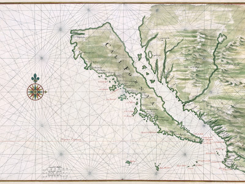
These Maps Reveal the Worst Atlas Blunders in History
Where on Earth is "Australindia"?

Remember that time California was an island? Johannes Vingboons, who mapped out the West Coast (or coasts, in this case) around 1650, may be remembered for his incredible blunder, but because of incorrect Spanish accounts, the idea was surprisingly common among cartographers at the time. Astonishingly, many continued to believe California was an island until the 18th century!
It might seem like one isolated error, but history is full of them. A new book now promises to collect some of the worst mistakes in a single collection. The Phantom Atlas: The Greatest Myths, Lies and Blunders on Maps by Edward Brooke-Hitching details some of history’s memorable myths. “The Phantom Atlas is an atlas of the world not as it ever existed, but as it was thought to be,” the description reads.
Ever heard of the mountains of Kong? Probably not, seeing as they don’t exist, but during the 19th century many cartographers believed a mountain range stretched across the continent of Africa. Some of them believed in the mountains of the Moon, situated below the river Nile. It wasn’t until Louis Gustave Binger came along in 1889 to reveal that none of it was true.
John Cary produced this oh-so-accurate map in 1805.
In 1827, Thomas J. Maslen produced a map of Australia for his book The Friend of Australia. The giant river depicted below didn’t exist, but nobody knew for sure: At that time, the central areas were largely unexplored. Unfortunately, the reality is far less appealing: Some parts of the outback receive less than 150 millimeters of rainfall per year. Not quite the water-filled wonderland Maslen made it out to be.
"Anglicania" sounds like some sort of British theme park.
The Strait of Anian, another fictional waterway, was mainly based around the sheer belief that a North American passage from Europe to Asia would be awesome. That’s entirely true, but it wasn’t until 1850 that the real Northwest Passage was discovered. Before then, voyagers kept claiming that they totally sailed the strait, and cartographers kept putting the strait in their maps. In Adam Zuerner’s Americae tam Septentrionalis quam Meridionalis in Mappa Geographica Delineatio, pictured below, the strait appears just above the famously fictional Island of California:
When drunkenly boasting at the bar gets a little out of hand.
In the below image, Theodor de Bry drew a map of the New World in 1596. As you can see, he’s taken a stab at what Australia might look like, and it’s a bit…stretched. Terra Australis was invented with basically zero evidence: Greek philosophers simply assumed the world had to be balanced, so there must be something there. It wasn’t until 1642, when Abel Tasman undertook his voyage, that cartographers began to adjust their maps.
Even the illustrations can't quite believe this mess.
Not all creations stretched back so far. Crocker Land is a fictional North Pole continent, invented by Robert Edwin Peary in 1906. Peary just so happened to name the land after George Crocker, the banker who was giving him money for his voyages. Peary claims he spotted Crocker Land, and the San Francisco Call drew the continent for its readers in 1913. But Peary’s diaries don’t mention spotting Crocker Land on the day he claims, suggesting he made it up later.
Taking flattery to a whole new level.
You can see all of the misguided maps in the full atlas, available here on Amazon.